By Mary Knapp
The weekly Vegetation Condition Report maps below can be a valuable tool for making crop selection and marketing decisions.
The objective of these reports is to provide users with a means of assessing the relative condition of crops and grassland. The maps can be used to assess current plant growth rates, as well as comparisons to the previous year and relative to the 27-year average. The report is used by individual farmers and ranchers, the commodities market, and political leaders for assessing factors such as production potential and drought impact across their state.
The Vegetation Condition Report (VCR) maps were originally developed by Dr. Kevin Price, K-State professor emeritus of agronomy and geography. His pioneering work in this area is gratefully acknowledged.
The maps have recently been revised, using newer technology and enhanced sources of data. Dr. Nan An, Imaging Scientist, collaborated with Dr. Antonio Ray Asebedo, assistant professor and lab director of the Precision Agriculture Lab in the Department of Agronomy at Kansas State University, on the new VCR development. Multiple improvements have been made, such as new image processing algorithms with new remotely sensed data from EROS Data Center.
These improvements increase sensitivity for capturing more variability in plant biomass and photosynthetic capacity. However, the same format as the previous versions of the VCR maps was retained, thus allowing the transition to be as seamless as possible for the end user. For this spring, it was decided not to incorporate the snow cover data, which had been used in past years. However, this feature will be added back at a later date. In addition, production of the Corn Belt maps has been stopped, as the continental U.S. maps will provide the same data for these areas. Dr. Asebedo and Dr. An will continue development and improvement of the VCRs and other advanced maps.
The maps in this issue of the newsletter show the current state of photosynthetic activity in Kansas, and the continental U.S., with comments from Mary Knapp, assistant state climatologist:
Figure 1. The Vegetation Condition Report for Kansas for October 25 – October 31, 2016 from K-State’s Precision Agriculture Laboratory shows only light photosynthetic activity continues to be limited, with the highest NDVI values in the Arkansas River basin where irrigated alfalfa is common.
Figure 2. Compared to the previous year at this time for Kansas, the current Vegetation Condition Report for October 25 – October 31, 2016 from K-State’s Precision Agriculture Laboratory shows the largest area of higher vegetative activity is in north central Kansas. Pockets of delayed maturity and favorable rainfall continue to be the major contributors to this higher vegetative activity. Expanding drought conditions and the slow establishment of winter wheat in the Southwest into the South Central Divisions is visible as reduced NDVI values there. The low NDVI values in east central Kansas are due to persistent cloud cover.

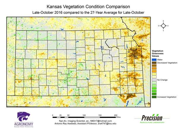
Figure 3. Compared to the 27-year average at this time for Kansas, this year’s Vegetation Condition Report for October 25 – October 31, 2016 from K-State’s Precision Agriculture Laboratory shows much of the state has close to average vegetative activity. Below-average values are visible in western Kansas, as abnormally dry conditions continue to expand eastward. The very low NDVI values in extreme eastern Kansas, however, are due to persistent cloud cover in the region.
Figure 4. The Vegetation Condition Report for the U.S for October 25 – October 314, 2016 from K-State’s Precision Agriculture Laboratory shows an area of high NDVI values in the Southeast as mild temperatures extend the growing season. Low NDVI values are visible in the Corn Belt and along the Mississippi River Valley, where crop maturity is ahead of average.
Figure 5. The U.S. comparison to last year at this time for October 25 – October 31, 2016 from K-State’s Precision Agriculture Laboratory shows that higher NDVI values in the Southern Plains where warmer-than-normal temperatures continue to be an issue. In the Southeast, NDVI values are lower as this region missed out on the recent tropical systems and drought continues to intensify. The much lower NDVI values in the along the Canadian border are due to persistent cloud cover.

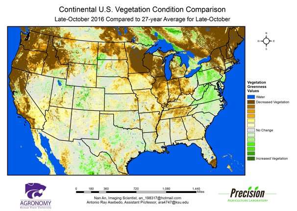
Figure 6. The U.S. comparison to the 27-year average for the period October 25 – October 31, 2016 from K-State’s Precision Agriculture Laboratory shows below-average photosynthetic activity in the Pacific Northwest and into the Great Lakes. Persistent rains and cloud cover are the major factors in this area. The South continues to have persistent drought conditions, but as photosynthetic activity is typically reduced in that region during this period, the low NDVI values due to the drought are not especially lower than the long-term average. In other seasons, the low NDVI values caused by the drought would show on the map as an area of below-average activity.