By Jenny Rees
With the dry conditions and various fires that have occurred, we have received questions regarding the nutrient value in the residue and/or soil impacts. The resources listed at the conclusion of this document can be of benefit to those impacted, particularly the South Dakota State University document in working through a potential value loss.
When residue is burned, most nitrogen and sulfur in the residue are lost to the atmosphere; however, the phosphorus and potassium are retained in the ash (as long as it doesn't blow away). In spite of this, short-term nutrient loss from the residue is minimal for most of our Nebraska soils.
Researchers from the University of Wisconsin looked at the need to replace nitrogen to the succeeding corn crop when soybean residue was either removed or not removed. They found no difference in nitrogen impacts to the corn crop regardless of whether the residue was removed; this suggests there is no need to replace the nitrogen in burnt soybean residue.
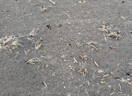
Figure 1. Corn residue burned by fire in York County, Nebraska in March 2022. (Photo by Jenny Rees)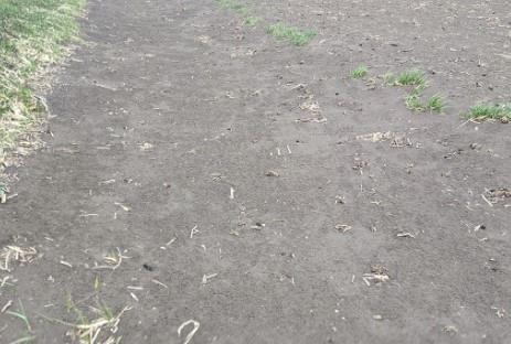
Figure 2. In this photo, silt loam soil has drifted into the ditch from strong winds in York County. (Photo by Jenny Rees)When looking at corn residue removal prior to corn planting, research from USDA-ARS in Nebraska also suggested no need to replace the nitrogen lost from the residue. They found increased mineralization due to the change in C:N ratio when residue was removed. Previous research compiled in this resource from South Dakota State shared the same sentiments.
Regarding longer-term nutrient loss, a UNL NebGuide shares for every 40 bu/ac of corn or sorghum, approximately one ton of residue is produced. Each ton of corn and sorghum residue contains approximately 17 lb N, 4 lb P2O5, 37 lb K, and 3 lb S. For every 30 bu/ac of soybean residue, approximately one ton of residue is produced with 17 lb N, 3 lb P2O5, 13 lb K, and 2 lb S for each ton of residue produced.
Perhaps the greatest losses to consider are organic matter, soil loss and soil moisture. Regarding organic matter, the soil holds the greatest portion of this. One year of residue is minimal, attributed with the potential of increasing organic matter 0.03-0.06%, depending on tillage type, crop, etc. Soil erosion due to wind/water can result in organic matter loss and loss of more productive soil. This is hard to quantify.
Examples
Soil moisture losses in no-till, non-irrigated fields — particularly in a dry year such as this — can be impactful. Former UNL Extension Irrigation Specialist Norman Klocke reported on Kansas research showing that leaving the residue in place resulted in a savings of 3.5 inches of soil water. Based on that, Bob Klein, Emeritus Crop Specialist shared, in a dryland situation, each additional inch of available water could translate into approximately 12 bushels of corn per acre for around 42 additional bushels of corn per acre (based on 3.5 inches).
The following are some examples of soil moisture impacts on yields provided by Paul Hay, Extension Educator Emeritus, and a Jefferson County farmer who shared their experiences.
Situation One
Fire across 30 acres of long-term no-till which was soybean stubble going to dryland corn. Fire occurred in fall after soybean harvest. Loss estimates of corn crop from crop insurance adjuster and Extension Educator Paul Hay were 26 and 28 bushels per acre.
Situation Two and Three
Fires in spring from escaped grass fire and burning barrel. Fires burned 13 and 38 acres of soybeans in corn stubble on long-term no-till. Insurance companies could not understand how new crop soybeans could be killed by fire. Replant is both situations were 4-6 bushels per acre less and were taller and some lodging occurred.
Situation Four
Three fires along highway from truck bearing. Fires occurred in early winter. Soybeans into long-term no-till corn stubble under a pivot — no measurable effect.
Dryland corn into long-term no-till soybean stubble — 15-20 bushel per acre loss.
Dryland soybeans in long-term no-till corn stubble — two to three bushel per acre reduction, beans were taller but lodging was not severe.
Example from a Jefferson County long-term no-till farmer: A wildfire burned across the corner of my Thayer County dryland farm six miles west of Daykin several years ago. This was dryland corn residue that burned in early spring, and then was planted to dryland beans. It was an average to slightly dry year for moisture. At harvest, the beans were noticeably shorter with less branching and less pods. The yield monitor showed five to 10 bushels less yield in the burned area. My explanation for the lower yield at the time was moisture loss due to no ground cover and greater evaporation.
Considerations
Use of soil moisture sensors can give an indication of soil moisture differences between burned and non-burned areas of fields or between fields. Direct yield comparisons between fields are difficult to make due to planting dates, hybrids/varieties, agronomic practices, etc., but important to still collect and assess.
Source : unl.edu