Optimizing Cattle & Timber Management
About 16% of all grazed land area in the United States is forested, and most of the livestock grazing of forested lands occurs in the Western U.S. While livestock grazing of forested lands has been occurring since the settlement era, relationships between livestock and timber management practices, and resource condition are not well understood. Silvopasture is being promoted by the USDA National Agroforestry Center as a practice that sustainably maximizes economic returns from combined livestock and timber production. There has also been renewed interest in multiple use of forests including: timber and livestock production, recreation, conservation, and preservation. In an effort to develop guidelines for cattle and timber management that optimize livestock and timber production while balancing economic and ecologic interests, we explored: 1) opportunities to incorporate Eastern U.S. silvopasture practices into Western U.S. forests with livestock grazing, 2) development of a forest density model to improve estimation of herbaceous forage production and facilitate livestock stocking decisions, and 3) relationships between livestock use, timber harvest history, and resource condition.
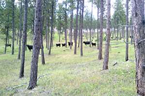
Basal Areas: Open tree spacing in pine forests promotes timber growth and forage production, providing economic opportunities for simultaneous timber and livestock production. Herbaceous forage and livestock production decrease with increasing tree canopy cover. Economic returns from combined timber and livestock production are maximized at tree basal areas between 30 and 60 ft2 per acre. A similar basal area also minimizes risk of timber loss associated with mountain pine beetle infestation.
Forest Density Maps: Forest density maps are an important tool that can inform management decisions. A temporal series of forest density maps covering the Black Hills from 1999 to 2015 were developed using high-resolution satellite imagery to calibrate lower resolution satellite imagery as an update to what is currently available from 2000. Forest density maps were then used to estimate forage production in the Black Hills.
Click here to see more...