Farms.com Home   News

Pasture and Rangeland Condition Update

By Will Secor

crop

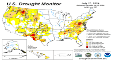
Pasture and rangeland conditions in the U.S. remain close to year-ago levels this week. Approximately 30 percent of pasture and rangeland are in poor to very-poor conditions. However, these conditions are not uniform across the U.S. Drought gripped the Southeast U.S. starting in June and has continued into July. More than 60 percent of the Southeast (AL, FL, GA, NC, SC, and VA) is experiencing drought. These drought conditions have hurt pasture and rangeland conditions in the Southeast. According to the USDA in mid-July, about 30 percent of the pasture in the Southeast (AL, AR, FL, GA, KY, LA, MS, NC, SC, TN, VA, WV) are in poor or very poor condition.

Some drought conditions exist in other areas of the country, as well, including approximately half of Texas, 60 percent of Oklahoma, 70 percent of Tennessee, and over 90 percent of Wyoming and Montana. Approximately 25 percent of Oklahoma and Texas pasture and rangelands are in poor or very poor condition. The Great Plains states are in better condition with around 20 percent of pasture and rangelands in the same condition.

These stable pasture and rangeland conditions year-over-year set the groundwork for a rebuild. With improved forage availability and lower feed costs, the ability of producers to expand their herds profitably increases. However, there are many factors that will play a key role in these rebuild decisions on an operation-by-operation basis, including expected future profitability, interest rates, land availability and other input cost changes.

Drought in certain areas and improved conditions in other areas creates uncertainty to the feeder cattle and calf price outlook for this fall. If drought incentivizes producers to bring more calves to market compared to normal, calf prices may see a more pronounced seasonal dip this fall in those areas, while still remaining high compared to recent history. However, in areas with good conditions, calf supplies may remain tight this fall, pushing prices higher than expected.

Source : osu.edu

Trending Video

Spring 2026 weather outlook for Wisconsin; What an early-arriving El Niño could mean

Video: Spring 2026 weather outlook for Wisconsin; What an early-arriving El Niño could mean

Northeast Wisconsin is a small corner of the world, but our weather is still affected by what happens across the globe.

That includes in the equatorial Pacific, where changes between El Niño and La Niña play a role in the weather here -- and boy, have there been some abrupt changes as of late.

El Niño and La Niña are the two phases of what is collectively known as the El Niño Southern Oscillation, or ENSO for short. These are the swings back and forth from unusually warm to unusually cold sea surface temperatures in the Pacific Ocean along the equator.

Since this past September, we have been in a weak La Niña, which means water temperatures near the Eastern Pacific equator have been cooler than usual. That's where we're at right now.

Even last fall, the long-term outlook suggested a return to neutral conditions by spring and potentially El Niño conditions by summer.

But there are some signs this may be happening faster than usual, which could accelerate the onset of El Niño.

Over the last few weeks, unusually strong bursts of westerly winds farther west in the Pacific -- where sea surface temperatures are warmer than average -- have been observed. There is a chance that this could accelerate the warming of those eastern Pacific waters and potentially push us into El Niño sooner than usual.

If we do enter El Nino by spring -- which we'll define as the period of March, April and May -- there are some long-term correlations with our weather here in Northeast Wisconsin.

Looking at a map of anomalously warm weather, most of the upper Great Lakes doesn't show a strong correlation, but in general, the northern tiers of the United States do tend to lean to that direction.

The stronger correlation is with precipitation. El Niño conditions in spring have historically come with a higher risk of very dry weather over that time frame, so this will definitely be a transition we'll have to watch closely as we move out of winter.