Farms.com Home   News

Registrations for Spotted Wing Drosophila 2018

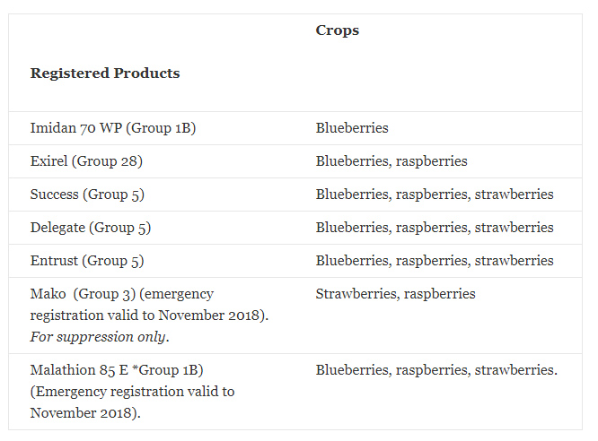
Seven insecticides are registered for spotted wing Drosophila (SWD) management this season, including two emergency use registrations: Mako and Malathion 85 E. Thanks to Jim Chaput, Minor Use Coordinator, for working on these emergency use registration submissions.

Open this PDF  Registrations for SWD June 2018 for the full infosheet, which includes rates, REI, PHI, Max applications, and re-treatment intervals.

Rotate between different chemical groups, re-apply every 5-7 days and re-apply after a rain.

SWD management is an integrated approach. Check out this blog post from May 16  for more on different management practices.

Source : ONfruit

Trending Video

Spring 2026 weather outlook for Wisconsin; What an early-arriving El Niño could mean

Video: Spring 2026 weather outlook for Wisconsin; What an early-arriving El Niño could mean

Northeast Wisconsin is a small corner of the world, but our weather is still affected by what happens across the globe.

That includes in the equatorial Pacific, where changes between El Niño and La Niña play a role in the weather here -- and boy, have there been some abrupt changes as of late.

El Niño and La Niña are the two phases of what is collectively known as the El Niño Southern Oscillation, or ENSO for short. These are the swings back and forth from unusually warm to unusually cold sea surface temperatures in the Pacific Ocean along the equator.

Since this past September, we have been in a weak La Niña, which means water temperatures near the Eastern Pacific equator have been cooler than usual. That's where we're at right now.

Even last fall, the long-term outlook suggested a return to neutral conditions by spring and potentially El Niño conditions by summer.

But there are some signs this may be happening faster than usual, which could accelerate the onset of El Niño.

Over the last few weeks, unusually strong bursts of westerly winds farther west in the Pacific -- where sea surface temperatures are warmer than average -- have been observed. There is a chance that this could accelerate the warming of those eastern Pacific waters and potentially push us into El Niño sooner than usual.

If we do enter El Nino by spring -- which we'll define as the period of March, April and May -- there are some long-term correlations with our weather here in Northeast Wisconsin.

Looking at a map of anomalously warm weather, most of the upper Great Lakes doesn't show a strong correlation, but in general, the northern tiers of the United States do tend to lean to that direction.

The stronger correlation is with precipitation. El Niño conditions in spring have historically come with a higher risk of very dry weather over that time frame, so this will definitely be a transition we'll have to watch closely as we move out of winter.