By Mary Knapp
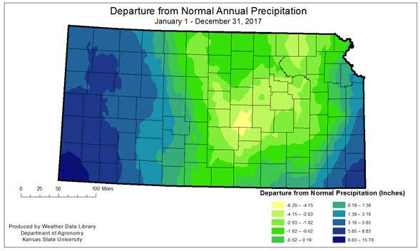
Despite a very wet January, drought of various stages covered over 80 percent of Kansas at the start of 2017. By the first of May the state was drought free, however a dry pattern developed. Abnormally dry conditions started to emerge by the first of July, particularly in the North Central and South Central Divisions. A pattern of much below-normal precipitation that began in October resulted in a rapid expansion of drought conditions. By the end of December, almost ten percent of the state, mainly in the Southwestern Division, had degraded to severe drought conditions. Conditions from abnormally dry to moderate drought expanded across the rest of the state. With the bookend dryness, this year ranked towards the dry end of the middle range, as the 74th driest since 1895. State-wide average precipitation was below-normal for the first three months, but switched to a wetter pattern in April. By May, only the East Central Division was below-average for the year-to-date. The Southwestern Division averaged 4.70 inches in April or almost 3 times the normal for the month. However, the year ended on a dry note, which started in September in the southwest, and progressed to the rest of the state from October through December. December state-wide average precipitation was 0.08 inches, just 5 percent of the normal December total. The greatest annual total for the year at a National Weather Service Cooperative station was 54.40 inches at Erie 1N in Neosho County. The greatest annual total for a CoCoRaHS station 57.24 inches at Farlington 0.8 NNE, Crawford County. The driest reporting station was the Russell Airport, in Russell County, with 17.28 inches. The greatest 24hr precipitation total reported at a CoCoRaHS station was 8.30 inches at Wellsville 3.6 NNW, Douglas County, on August 22nd. The greatest 24hr precipitation total reported at a NWS station was 8.85 inches at Hillsdale Lake, Miami County, also on August 22nd.

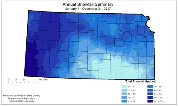
Snow was not much of a factor in 2017, although there were several large events. The first major event was in January, where an ice event in southwest Kansas was followed by up to 6 inches of snow. February through March saw some snow events, but generally lighter than usual. The most noteworthy snowstorm was the blizzard that hit western Kansas at the end of April through the first of May. Thirteen stations recorded record amounts of snow for the three-day spring storm ending on the 1st of May. The greatest total for the year was 35.3 inches at Johnson, Stanton County. Most of that came during the April event. Damage from the event is still being collected, but included downed power lines/power poles, tree damage, livestock deaths, and damage to winter wheat. The state average annual snowfall for 2017 was 4.2 inches, below last year’s average of 6.6 inches, well below 2015’s of over 8.6 inches. The greatest snowfall totals were seen in the Western Division, while several stations reported no snow at all in 2017. In the eastern third of the state, much of the moisture that ended the month of April came as rain not snow. A map which illustrates the snowfall distribution across the state for 2017 is included below.

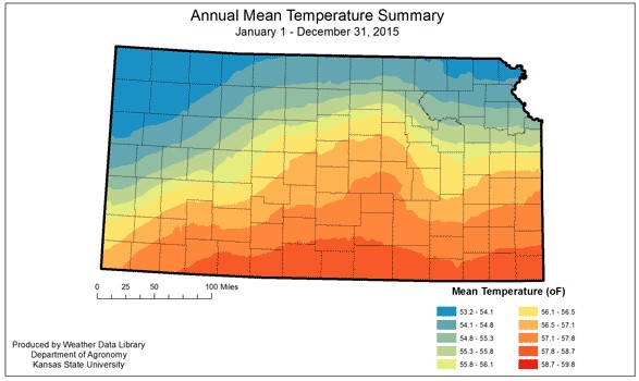
Temperatures averaged above-normal for the year, but not to the degree of 2016. State-wide average temperature in 2017 was 56.6 degrees F, which places it as the 21st warmest on record where 2016 was the 9th warmest. Only May and August averaged below-normal. February had the greatest departure from normal, with an average of 41.9 degrees F, or 7.9 degrees warmer-than-normal. Temperatures fluctuated considerably during the year, ranging from 111 degrees F at the Salina Airport, Saline County on July 22nd to -15 degrees F at Clinton Lake, Douglas County, on January 6th. Despite being warmer-than-average, all divisions also saw temperatures plunge below zero. Even the Southeast Division recorded sub-zero temperatures, the coldest of which was a -4 degrees F at Winfield 3NE, Cowley County, on December 31st. The average date for the last spring freeze was April 14th. The earliest start to the growing season was a last freeze on March 15th at various locations in the South Central Division. Russell Springs 3N, Logan County, had the latest freezing temperature in the spring with 31 degrees F reported on May 5th.
The first fall freeze was mostly seasonal state-wide. The average date was October 22nd. The earliest first frost was reported on October 10th at Goodland, in Sherman County. The latest first frost was reported at Fredonia, Wilson County, on October 29th when temperatures dropped to 27 degrees F. The average length of the growing season was 190 days. The shortest growing season was at multiple locations in northwest and west central Kansas with 158 days. The station with the longest growing season was the Coffeyville Municipal Airport, Montgomery County, with a growing season of 226 days.

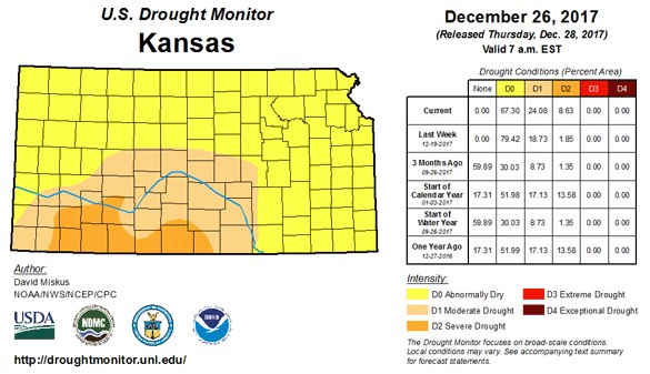
Drought conditions have shifted over the year, with just a short period that was drought-free. The year started with much of the western third of the state in moderate to severe drought. Heavy spring moisture resulted in the state being drought-free by the end of April. This lasted for 6 weeks, with abnormally dry conditions developing first in the North Central Division. Despite the overall wetter-than-average year in the Southwest Division, lack of moisture in the late fall resulted in deterioration. Conditions declined most quickly in the South Central Division, with severe drought conditions in that part of the state. At the end of December almost 9 percent of the state is in severe drought. The rapid switch from extremely wet conditions to extremely dry conditions created problems with establishment of fall seed crops, such as winter wheat and canola. The continued dry weather, coupled with warmer-than-normal temperatures in November meant abnormally dry conditions spread across the state. Currently, approximately 63 percent of the state is in abnormally dry conditions, and an additional 24 percent of the state is in moderate drought. Just over 8 percent of the state is in severe drought. Little improvement is expected during the winter, and the severe drought might continue to push north and eastward. Normal spring rains are critical for any improvement in drought conditions. The El Niño/Southern Oscillation (ENSO) is expected to be in the La Niña phase as we move into the spring. This gives little confidence in increased moisture across the region, and the pattern is expected to continue into the spring.

The severe weather season wasn’t as active as in 2016, nor as active as the 5-year average. Preliminary numbers from the Storm Prediction Center (SPC) show a total of 74 tornadoes in 2017, compared to a total of 99 tornadoes in 2016, and the five-year average (2008-2012) of 116 tornadoes. In contrast, hail and damaging wind reports were higher in 2017, with 590 hail reports versus 569 hail reports in 2016 and 580 damaging wind reports versus 539 damaging wind reports in 2016. Data on other severe weather events are available from the National Climatic Data Center (NCDC) storm database, but only through September.
For the period from January to September, there were 129 flood or flash flood events affecting over 49 counties. There was one fatality from the flood events, in Miami County on the 22nd of August. Preliminary damage reports total to property and crops from the floods was approximately 27 thousand dollars. Generally, these property and crop damage reports are underestimated. In many cases, crop damage isn’t immediately available and fails to be included in the storm total. Likewise, property damage that is from uninsured losses often is also missing in the overall total.
There were no excessive heat events reported in 2017. There were 107 winter weather reports, including cold temperatures, snow, ice storms, through September, with the most intense occurring at the end of April. This total does not include the winter weather with extremely cold temperatures in December.
Click here to see more...