By Jim Noel
There are challenges ahead so we will break them into short-term and long-term.
Short-term
The recent snow was a rare event for the amount that fell across Ohio. However, the minimum temperatures in the 20s and 30s was not that far off of normal for last freeze conditions for Ohio.

The strongest typhoon ever in the northern hemisphere occurred east of the Philippines last week and this energy will come across parts of North America over the next week. When that happens weather model performance often drops. Hence, if you see more bouncing around of forecasts the next 10-15 days that may be one reason why.
We have a big warm-up the first half of this week ahead of a strong storm that will move through Ohio the second half of the week with wind and rain. We could see anywhere from 0.50 inches to over 2 inches across Ohio later this week but placement is not certain and seems to favor central and southern Ohio with the highest amounts. Expect most places to see an inch or less given recent track record of events coming in lighter. Once the storm passes colder air will push in and some frost will be possible this weekend with lows in the 30s.
The rainfall the next 30-days is critical for the growing season as moderate drought over northern Ohio already has soil conditions in a shortage.
The latest drought monitor can be found here:
https://droughtmonitor.unl.edu
Also, some of the greatest evaporative demand in the country has been in parts of northern Ohio the last 30+ days and can be monitored as a leading indicator for drought development at this webpage via NOAA:
https://psl.noaa.gov/eddi/realtime_maps/images/latest.trim.png
You can keep up on the Ohio River Forecast Center's Water Resources Outlooks at:
https://www.weather.gov/ohrfc/WRO
Long-term
May appears will see periods of well above and below normal temperatures but will average out close to normal or just slightly above normal. Precipitation continues to trend at or below normal but models suggest a normal May for precipitation. If we get timely rains that will help soil conditions for summer. If we miss critical rains in May, this could lead to summer issues.
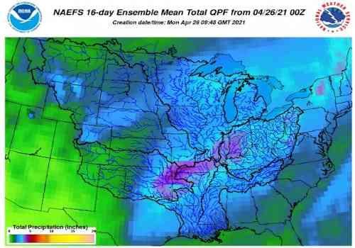
The latest rainfall outlook for the next 16-days is viewable in the attached image. Normal rainfall is nearing 2 inches for the next 16-days. We expect 1-3 inches for most areas.
For summer, most climate models indicate above normal temperatures and medium to high confidence of above normal temperatures during typical peak temperatures from mid-June to mid-August. We will need to monitor this. Confidence in summer rainfall is low. Most outlooks and models suggest not too far from normal rainfall but the reality is since 30-50% of summer rainfall comes from local soils, the next 30-days will be a big player in our summer rainfall outcome.
Source : osu.edu