By Jim Noel
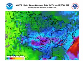
The overall drier pattern in many but not all places in Ohio this summer appears like it will relax closer to normal in August. The greatest uncertainty with the outlook will center around how the tropical moisture impacts the eastern United States.

The August outlook for temperatures indicates 1-2F above normal but a lot closer to normal than what we have seen this summer with the heat. The last time we have seen this much hot weather was 2015 and 2012. The good news is the worst of the heat for 2020 appears over. What this means is we should see a lot more maximum temperatures in the 80s with some 90s thrown in. Expected minimum temperatures mostly in the 60s to lower 70s.
The August outlook for rainfall indicates somewhat improving conditions. There is uncertainty here due to tropical moisture and where it flows. Normal rainfall is in the 3-4 inch range and rainfall is expected to average in the 2-4 inches range with a few higher totals. This will put us a lot closer to normal wetness. The 2 inch totals are more likely in northern Ohio and the 4 inches totals are more likely in southern Ohio.
It appears that the scattered drought conditions in Ohio are likely peaking and some improvement is possible over the next several months.
The outlook for September to November for the end of growing season into harvest season suggests warmer than normal weather will persist and low chances for an early freeze. Rainfall is shaping up to not be too far from normal.
Source : osu.edu