By Al Dutcher
The Climate Prediction Center (CPC) released the equivalent of their spring outlook on Feb. 17, along with their rolling three-month outlooks through the March-May 2022 period for temperatures and precipitation. The temperature and precipitation outlooks for the next three months can be viewed in Figure 1 (temperature) and Figure 2 (precipitation).
From CPC’s perspective, most areas east of the Rocky Mountains are forecast to see above normal temperatures, with the highest probability of occurrence odds assigned to the southwestern half of Texas and the southeastern quarter of New Mexico. The only area of the continental United States that is favored to receive below normal temperatures includes the northwestern half of Oregon, all of Washington, the northern third of Idaho and the northwestern third of Montana.
Nebraska lies on the northern periphery of the above normal temperature forecast with odds slightly tilted toward these conditions. The entire state has been assigned a 33-40% chance of above normal temperatures, 33% of normal temperatures and a 26-33% chance of below normal temperatures.
Above normal precipitation over the next three months is projected to occur across the Ohio River Valley and the northwestern United States. However, a dry signal is indicated for the western half of the central and southern High Plains region, with the highest probability of occurrence assigned to the four corners region of the United States (CO, UT, NV, NM). CPC has assigned a 50-60% probability that this region will experience below normal moisture, with a 33% chance of normal precipitation and a 7-17% chance of above normal moisture.
Delving deeper into the Nebraska outlook, CPC indicates the southern three-fourths of the Panhandle, the western Sandhill region and southwest Nebraska have been assigned a 40-50% probability of below normal moisture. The odds for normal moisture is 33%, with a 17-27% chance of above normal moisture. The northern Panhandle and the central one-third of Nebraska have been assigned a 33-40% chance of below normal moisture, 33% chance of normal moisture and a 27-33% chance of above normal moisture. For the remainder of the state, CPC has assigned equal odds (33% chance) of receiving normal, above normal or below normal precipitation.
If CPC’s forecast verifies, drought conditions across the western half of the state will intensify due to the lack of subsoil moisture recharge and a poor finish to the snowpack season across northern Colorado. Conversely, the strong signal for above normal moisture in the Ohio River valley would intensify wetness concerns dating back to last fall. Much of this region has received 10-18 inches of moisture since the beginning of last October.
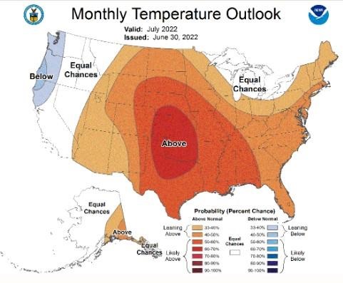 Figure 1. March through May 2022 national temperature outlook.
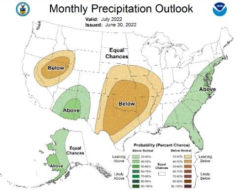 Figure 2. March through May 2022 national precipitation outlook.
My Thoughts on CPC’s Outlook
To be blunt, if CPC’s temperature and precipitation outlook for the next three months were to verify, drought conditions across western Nebraska would intensify rapidly. The western two-thirds of the state missed out on the October precipitation events that hit eastern Nebraska and the dry conditions this winter have only intensified the lack of subsoil moisture recharge. In fact, the dryness this winter has eliminated the surplus precipitation that eastern Nebraska received last fall. Without normal moisture this spring, areas of eastern Nebraska currently depicted as abnormally dry by the U.S. Drought Monitor would be expected to see moderate drought conditions develop before the end of this spring.
The lack of snowfall this winter has provided producers ample opportunity to do field maintenance projects, while ranchers have been able to graze cattle without the need of significant supplemental feed due to the lack of snow cover. For non-agricultural sectors of the Nebraska economy, the lack of snow has been a boon to city snow removal budgets and less energy demand used for winter heating by consumers.
Since the beginning of 2022, a strong upper air trough anchored over the Hudson Bay region has resulted in persistent cold across the western Great Lakes region. The Minnesota state climate office has indicated that at least 15 Alberta clipper systems have hit northern Minnesota since winter began. Here in Nebraska, these same systems pushed dry cold fronts through the state because of the lack of moisture, since these polar fronts moving southward originated out of northern Canada, far from any source of ocean water vapor.
There has been a subtle change to this pattern recently as two major winter storms have move across the southern High Plains region into the Ohio River valley. Although these two systems bypassed us to the south, they have provided beneficial surface moisture to the eastern half of Kansas, Oklahoma and Texas.
If this trend continues, low le
Figure 3. Sixty-day subsurface heat content for the Equatorial Pacific.
Source : unl.edu