By Aaron Wilson
Temperatures across Ohio have been running 2-6°F above average (1991-2010; Figure 1) during the month of December, almost guaranteeing another top 10 warmest year on record for the Buckeye State (1895-present). Daily average soil temperatures remain above freezing, with upper 30s to low 40s across the north and low to mid 40s across central and southern counties.
Precipitation, mainly in the form of rain, has been plentiful as well with a large portion of the state picking up 2-4 inches of precipitation since December 1. Pockets of heavier precipitation can be found across portions of southwest, north central, and southern Ohio. Snowfall has been very light, even across the snowbelt areas of the northeast, with less than 1 inch statewide.
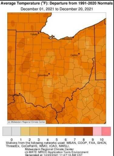
Figure 1). Accumulated precipitation for December 1 - 20, 2021. Figure courtesy of the Midwestern Regional Climate Center
Forecast
High pressure will remain anchored across the Ohio Valley for the next couple of days, with cool daytime highs in theDay 11 image not available upper 30s to mid 40s. A weak cold front could bring a few snow showers in its wake to northeastern counties on Wednesday along with colder temperatures statewide. A stronger low-pressure system will push toward the Great Lakes on Friday, bringing a surge of warmer air and rain showers to the region through Friday night into Christmas morning. Conditions will slowly dry out on Christmas Day with mild temperatures in upper 40s to low 50s. Seasonally average temperatures should follow for the beginning of next week. The Weather Prediction Center is currently predicting up to 0.50 inches of precipitation over the next 7 days (Figure 2).
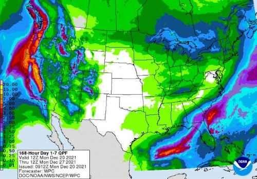
Figure 2). Precipitation forecast from the Weather Prediction Center for 7a Monday Dec 20 – 7a Monday Dec 27.
The Climate Prediction Center’s 6–10-day outlook for the period of December 26 - 30, 2021 and the 16-Day Rainfall Outlook from NOAA/NWS/Ohio River Forecast Center indicate that temperatures are likely to be above average with above average precipitation (Figure 3). Climate averages for this period include a high temperature range of 37-41°F, a low temperature range of 23-26°F, and average rainfall of 0.55-0.85 inches.
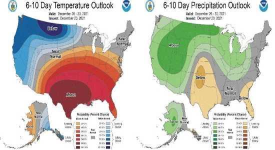
Figure 3) Climate Prediction Center 6-10 Day Outlook valid for December 26 - 30, 2021, for left) temperatures and right) precipitation. Colors represent the probability of below, normal, or above normal conditions.
Source : osu.edu